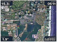
Point Your Boat in the Right Direction with 2011 Marine Maps
Spring has sprung! That means mariners far and wide are ready to hit the water in search of sun, fish, and fun. We know that in addition to some seasonal fine-tuning, those on the water also want to have the most-up-to-date charts available. And to help you navigate the waves with confidence, we recently released the 2011 versions of our BlueChart g2 and BlueChart g2 Vision marine cartography. Our unique BlueChart maps make it easy to see and identify intertidal zones, depth contours, spot soundings, navaids, wrecks, obstructions and more. The new BlueChart data also adds increased detail and offers improved transition between zoom levels and harmonious changes across chart boundaries.
The post Point Your Boat in the Right Direction with 2011 Marine Maps appeared first on Garmin Blog.
Sample Block Quote
Praesent vestibulum congue tellus at fringilla. Curabitur vitae semper sem, eu convallis est. Cras felis nunc commodo loremous convallis vitae interdum non nisl. Maecenas ac est sit amet augue pharetra convallis nec danos.
Sample Paragraph Text
Praesent vestibulum congue tellus at fringilla. Curabitur vitae semper sem, eu convallis est. Cras felis nunc commodo eu convallis vitae interdum non nisl. Maecenas ac est sit amet augue pharetra convallis nec danos dui.
Cras suscipit quam et turpis eleifend vitae malesuada magna congue. Damus id ullamcorper neque. Sed vitae mi a mi pretium aliquet ac sed elitos. Pellentesque nulla eros accumsan quis justo at tincidunt lobortis denimes loremous. Suspendisse vestibulum lectus in lectus volutpat, ut dapibus purus pulvinar. Vestibulum sit amet auctor ipsum.


