Updated Garmin StreetPilot Onboard App Helps Drivers to Avoid Thanksgiving Gridlock with Real-Time Traffic Photos
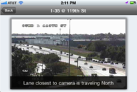
 “photoLive Traffic Cameras is an addition to Garmin’s existing real-time traffic feature, which guides drivers around congestion. But just as in other life situations, it’s sometimes best to see things with your own eyes rather than relying solely on data,” said Gerhard Mayr, Garmin vice-president ofworldwide mobile phone business. “The new photoLive feature lets you easily look up real-time photos from traffic cameras across the U.S. and Canada to get a glance at traffic and weather conditions.”
photoLive Traffic Cameras can easily be accessed through the StreetPilot app’s traffic menu. Users simply select the road they’d like to look at and the feature displays real-time photos from that location. Included are over 10,000 traffic cameras across the U.S. and Canada that send images every couple of minutes to make sure users get the most current view. Users can also save their favorite cameras for quick one-touch access.
Additional Features included in the StreetPilot App Update:
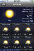
 Weather: View weather conditions and five-day forecasts for your current location or for your
destination.
Points of Interest Sharing: Let friends and family know where you are or when you’re arriving at a point of interest such as a restaurant or attraction. With the touch of a button, you can share a location via Facebook or SMS and even include a personal message.
InstaSearch: The new InstaSearch function allows users to accelerate searches. It automatically provides suggestions as you enter text to search for POIs, cities or addresses, making it easier to find what you’re looking for.
POI and Speed Limit Editor: Users can now delete or edit points of interest and add photos of a location. The changes can be uploaded to Garmin for database inclusion in future updates. Users can also update speed limits along a road segment.
Garmin StreetPilot Onboard puts the vast preloaded database and intuitive interface of a Garmin nüvi into the iPhone you use everyday – without tapping into your data plan. With ultra-fast map drawing, panning and zooming, the preloaded maps and Points of Interest offer peace of mind in knowing that wireless coverage and data plan usage are not required to access maps or calculate routes. So just as with a nüvi, the maps and directions are always there when you need them most – especially when you can’t get cell or Wi-Fi signals or your data plan is running low.
With advanced navigation features such as lane guidance, junction view, 3D buildings, trip planner, trip computer, Garmin’s “Where Am I?” safety feature, and red-light and speed camera information, Garmin StreetPilot Onboard provides crucial information that a driver needs for daily errands, weekend road trips or family vacations.
All Garmin StreetPilot apps are available from the App Store. Find details about each version – as well as Garmin’s other apps for a wide variety of activities – at http://garmin.com/apps.
The post Updated Garmin StreetPilot Onboard App Helps Drivers to Avoid Thanksgiving Gridlock with Real-Time Traffic Photos appeared first on Garmin Blog.
Sample Block Quote
Praesent vestibulum congue tellus at fringilla. Curabitur vitae semper sem, eu convallis est. Cras felis nunc commodo loremous convallis vitae interdum non nisl. Maecenas ac est sit amet augue pharetra convallis nec danos.
Sample Paragraph Text
Praesent vestibulum congue tellus at fringilla. Curabitur vitae semper sem, eu convallis est. Cras felis nunc commodo eu convallis vitae interdum non nisl. Maecenas ac est sit amet augue pharetra convallis nec danos dui.
Cras suscipit quam et turpis eleifend vitae malesuada magna congue. Damus id ullamcorper neque. Sed vitae mi a mi pretium aliquet ac sed elitos. Pellentesque nulla eros accumsan quis justo at tincidunt lobortis denimes loremous. Suspendisse vestibulum lectus in lectus volutpat, ut dapibus purus pulvinar. Vestibulum sit amet auctor ipsum.

