The Wandering Trio: Biking and Mountaineering in Peru – Part 2
Three recent graduates set out on a trip aimed to combine their passion for alpinism, experiencing new cultures, and biking into one adventure. This is not the first time these disciplines have been combined in the Peruvian Andes, but that didn’t make this any less difficult.
The team was made up of Kevin Trippe, Nathanial Iltis, and Pyper Dixon. Kevin and Pyper worked as ice climbing guides in Alaska, while Nathan was a frequent backcountry skier in Montana. Nathan is also the best biker in their group and the only one with any mechanical knowledge. He quickly became the resident bike mechanic. Pyper supplied the team with his prior knowledge of biking in foreign countries, as well as his stubbornness to see any foolhardy plan through to completion. Here are the guys, in their own words, recounting their exciting journey inside Peru.
Last week we shared Kevin, Pyper and Nathan’s adventure from Lima to Huaraz. Here is the second part to their crazy adventure in their words:
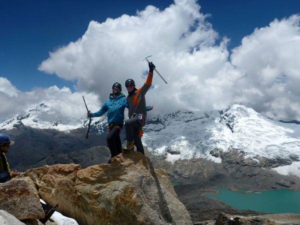
Since we were all new to climbing high elevations, our goals were modest. We were interested in learning what expedition climbing was about. We soon realized every step of an expedition requires time and often-lengthy discussion. Planning the logistics of climbing with five people led to many disagreements on what was essential. Are we bring too much peanut butter or should we use burros a lot were some of the disagreements that ensued. Once the planning was complete we begun summiting Urus Estes and Ishinca. Urus Estes would be our acclimatization peak: its summit is at 17,782 feet. We learned immediately upon entering the Ishinca Valley that our climbing guidebook was out of date due to rapid glacial recession throughout the Cordillera Blanca. Despite this, route finding the climb up Urus was straightforward, though all of us struggled with the effects of high elevation. Fresh snow slowed our pace and the increasing altitude further limited quick movement. Upon reaching the summit we shouted as much as the thin air would allow us and descended down easily to camp.
Enjoying the summit views from Urus Estes. Photo Credit: N. Iltis
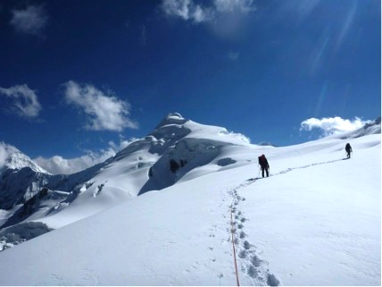
After a day of rest, we woke up, chugged coffee, and hiked by the light of our headlamps towards Ishinca. Based on what we had seen from the top of Urus we planned to climb the SW ridge of the mountain and descend across the NW slopes. If successful we would traverse the entire peak. As we began roped travel up the glacier, the crux of the mountain presented itself in a narrow corniced (unstable overhanging snow) pinched underneath the summit. Just below this point, nausea and altitude forced Henry to descend, leaving a rope team of four. We continued forward into the narrow ridge, breaking trail into the snow up past our waists. As we reached the thinnest point, we heard whoomphing sounds and slab avalanches begin to trigger to our right. We pushed forward towards the flatter, wider part of the ridge ahead. We walk the fracture in between the corniced ridge and the avalanche zone, now realizing why few people choose to climb in the offseason. We pitch out the summit and my fēnix 3 reads 18,143 ft. Our descent down the NW slopes is long and tedious. We reach frequent dead ends and backtrack often. We finally make our way off the glacier, and return to base camp exhausted.
Starting our progress up the Ishinca glacier, the avalanche zone is just visible beneath the summit cone at the narrowest part of the ridge. Photo Credit: N. Iltis
We realized after Ishinca that any taller objectives we had planned to climb next would be too dangerous, as snow conditions were likely to be unstable at higher elevations. Instead we planned a trip to climb Yanapaccha, a moderately technical mountain that stands just under 18,000 ft. We packed our gear for an overnight outing and jammed ourselves in a crowded minibus. Just as the bus begun to trundle away from the trailhead our fēnix 3’s beeped with a storm-warning alert. We began hiking in the afternoon rain towards base camp to drop off our gear and see the view of our route for the following day. Unfortunately, a low cloud layer meant that we had no view of the mountain, and were unable to route find.
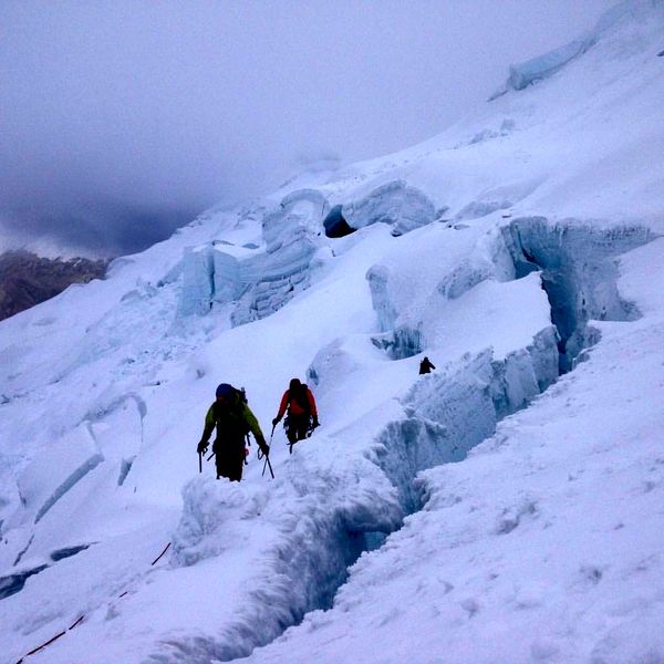
The next day we awoke at 4 am. There was a narrow window to climb, as we needed daylight to route find, but must descend before the afternoon storms. As we are traveling on the glacier, Pyper falls into a small crevasse up to his waist, though he is able to easily extricate himself. As we continue to progress up into the steeper sections of the mountain, it eventually becomes necessary to climb a section one at a time with snow protection. As we start climbing the clouds rolled in, dropping visibility to 40 feet. We were forced to turn back the way we came, disappointed once again at the poor conditions.
Negotiating crevasses on our way up Yanapaccha, desperately hoping the fog bank behind us doesn't fully envelop the mountain. Photo Credit: P. Dixon
Although it was frustrating that we were unable to climb any larger objectives, all of us agreed that our climbing in the Cordillera Blanca was a success. We went into this trip with the goal of learning how to climb high-elevation summits. Although we were more “successful” climbing, everything this trip entailed made us into better mountaineers. Everything we see from famous climbers shows gnarly, seemingly impossible ascents. However, alpine climbing is a process. Summit photos don’t show the vast amount of logistical planning it takes to get there. Only by gaining experience in the multiple facets of mountaineering can the everyday climber be successful in big alpine objectives.
There are outdoor adventures all over the world and these three guys were lucky enough to experience one amazing trip. Stay tuned for their VIRB XE video in the following weeks and Don’t forget to share with us on Facebook, Twitter, Instagram and use #HaveNoLimits.
The post The Wandering Trio: Biking and Mountaineering in Peru – Part 2 appeared first on Garmin Blog.
Sample Block Quote
Praesent vestibulum congue tellus at fringilla. Curabitur vitae semper sem, eu convallis est. Cras felis nunc commodo loremous convallis vitae interdum non nisl. Maecenas ac est sit amet augue pharetra convallis nec danos.
Sample Paragraph Text
Praesent vestibulum congue tellus at fringilla. Curabitur vitae semper sem, eu convallis est. Cras felis nunc commodo eu convallis vitae interdum non nisl. Maecenas ac est sit amet augue pharetra convallis nec danos dui.
Cras suscipit quam et turpis eleifend vitae malesuada magna congue. Damus id ullamcorper neque. Sed vitae mi a mi pretium aliquet ac sed elitos. Pellentesque nulla eros accumsan quis justo at tincidunt lobortis denimes loremous. Suspendisse vestibulum lectus in lectus volutpat, ut dapibus purus pulvinar. Vestibulum sit amet auctor ipsum.


