Ride the Rockies: They’re Baaack!
RTR: Read the Route
 Every year thousands of cyclists wait with anticipation for the announcement of the Ride the Rockies route in the Denver Post. Each of the prior 2 years, I looked forward to seeing parts of the state I’d never been to. Neither time was I disappointed. This year I’ve been to most of the towns on the route and I’m even more excited. I get to look forward with a vision of where we’ll actually be. Let’s see if I can describe some of it…
For the first time in my short RTR history, the route is a loop that starts and ends in Frisco, a great mountain town in Summit County. The first day is a 98 (!) mile/4,700 ft elevation gain trek through Kremmling over Rabbit Ears Pass to Steamboat Springs. I’ve biked the section from Frisco (okay, Silverthorne, but close enough) to Kremmling. That part is mostly DOWN HILL for 35 miles – a fun way to start RTR. But then we’ll be climbing up and over the pass. A long ride but not too gnarly as far as passes go. The profile for the top of Rabbit Ears Pass looks more like angry monster teeth than a rabbit’s ears. . . I love the fact that the downhill side is the steeper side. Steamboat is a beautiful area surrounded by rolling hills and farms from what I remember – I was only there twice, without my bike.
I’ve never been to Craig, but it must be the same beautiful terrain as Steamboat because Day 2 is only 44 miles away and mostly flat. 700 ft elevation gain. I didn’t know there was any part of western Colorado so flat! Ahhhhh . . . . relief.
Day 3 is another long one – 89 miles/4,400 ft to Rifle. I’ve never been there either . . . and after 89 miles I might be ready to get to bed early.
 Luckily, Day 4 is the shortest – 36 miles/2,200 ft to Glenwood Springs. I’ve done the last ~8 miles of that ride, as part of the 2001 Glenwood Triathlon. (The bike section was an out and back from the town.) Historic town best known for its GIANT hot springs pools. Also has a brewery or 2 (then again, what Colorado town doesn’t?)
I’m really looking forward to Day 5, (43 miles/2,800ft) to Aspen. It’s not the short day that’s appealing (okay – it’s that too), but the fact that I have driven this valley countless times on my way to Aspen (my brother lives there). It is absolutely gorgeous – I am constantly amazed by the variety of colors: soft green grass, darker green forest trees, red clay-based rocks on the sides of some of the hills white limestone on others, plus the amazing snow-capped Mt. Sopris to the south. Closer to Aspen, the ski areas come into view. I can’t wait to see it from the (relative) slow speed of my bike seat.
Looking forward to relaxing in Aspen, although I’ll have to be a good girl and get to bed early, because Day 6 is our toughest. See my blog from last year about biking up Independence Pass – the most beautiful but toughest ride I’ve ever done. I’m only a little worried about that, and looking forward to the celebration at the summit. Can’t wait to ride down the far side. Must make sure my brakes are in good shape – and my lungs, as I’ll be screaming in fear and joy the whole way down. The only bummer is the 15 miles of uphill into Leadville at the end of this 61-mile/5,700 ft. gain day. UGH.
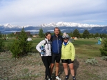
 We were in Leadville in ’05. A great time despite the rain and Daren’s swollen uvula. The school where we stay must have the best view of any high school in the country. –Leadville is at 10,200 – heavy breathing! The camp site is awesome – looking out over Mt. Massive (see picture). By then we’ll be starting our goodbyes.
Day 7 we finish with 51 miles/3,700 ft around Turquoise Lake, over Fremont Pass and into Frisco. We did most of this ride in ’05, but this year will be better with the addition of Turquoise Lake (I could skip it if I’m completely burnt, but I’ve never been so I want to check it out.) Fremont Pass is easy and the ride down to Frisco is all downhill. Two years ago we continued on 9 miles to finish in Breckenridge, UPHILL. I call that the longest 9 miles of my life – I so just wanted to be DONE. Not to be confused with last year up the south rim of the Royal Gorge on the last day of RTR ’06 — the hardest, steepest 2 miles I’ve ever seen on my bike.
It’s hard to believe it’s already June and RTR is just a few short weeks away, but I think I’m Ready to Rock! Check out my training ride from Memorial Day Weekend on MotionBased – 75 miles and 4,630 ft. of elevation gain!
The post Ride the Rockies: They’re Baaack! appeared first on Garmin Blog.
Sample Block Quote
Praesent vestibulum congue tellus at fringilla. Curabitur vitae semper sem, eu convallis est. Cras felis nunc commodo loremous convallis vitae interdum non nisl. Maecenas ac est sit amet augue pharetra convallis nec danos.
Sample Paragraph Text
Praesent vestibulum congue tellus at fringilla. Curabitur vitae semper sem, eu convallis est. Cras felis nunc commodo eu convallis vitae interdum non nisl. Maecenas ac est sit amet augue pharetra convallis nec danos dui.
Cras suscipit quam et turpis eleifend vitae malesuada magna congue. Damus id ullamcorper neque. Sed vitae mi a mi pretium aliquet ac sed elitos. Pellentesque nulla eros accumsan quis justo at tincidunt lobortis denimes loremous. Suspendisse vestibulum lectus in lectus volutpat, ut dapibus purus pulvinar. Vestibulum sit amet auctor ipsum.

