Mountain Guide Recounts 10-hour Trip Turned 24-hour Ordeal
In July 2019, mountain guide Susanna Girolamo led a hiking trip in Montana’s Swan Mountain Range. Little did she know it would become a much longer trip than anticipated. In her own words, Girolamo shared with Garmin the details of that day, and how carrying an inReach® satellite communicator stopped the situation from escalating.
“By the summer of 2019, I had been leading mountain and backcountry skiing trips for a few years, so my husband decided to buy me my own inReach Mini. In his words, it was ‘cheap insurance.’
“In July, it came in handy when I led a trip in Montana’s Swan Mountain Range that turned out to be a 24-hour outing instead of a 10- to 12-hour trip.
“That day, one of the trip members had underestimated the physical level of endurance required and slowed our pace down dramatically. We had to take great caution while navigating off-trail terrain, and frequent breaks were necessary.
“The Swan Range is a mountain range in western Montana, just southwest of Glacier National Park, and it runs about 99 miles from north to south. Its peaks rise to around 8,000’ to 9,000’.
“The traverse I planned didn’t have many access points such as roads or trails, so when we committed to it, we were truly committed. It’s away from other trails and has no cellphone service. The only way in and out is to stay on the ridge until you get back on the trail.
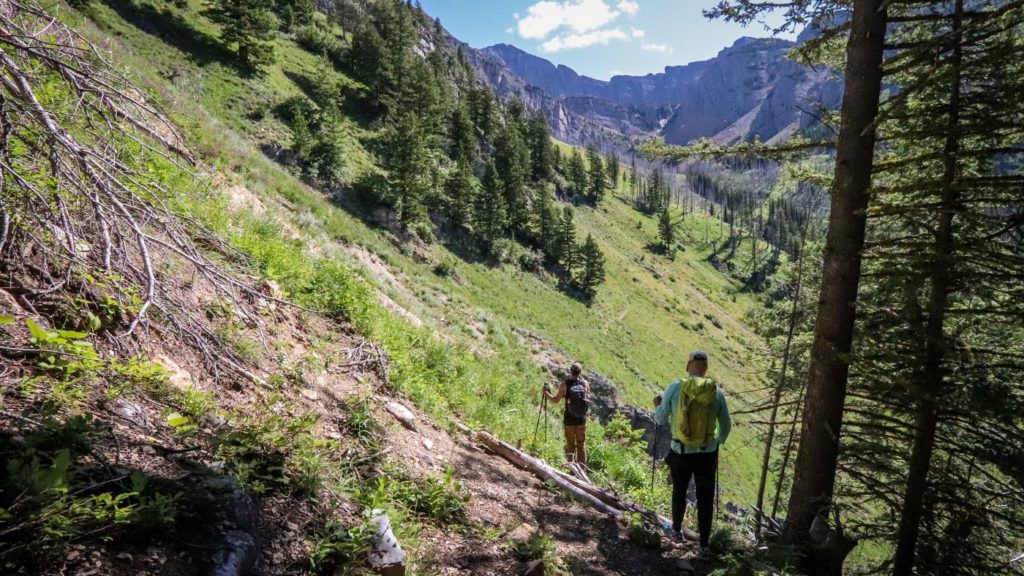
“The plan was to start at East Foothill Trailhead, hike up to Rumble Creek Lake, scramble up the gully just north of Holland Peak, traverse north on the ridge and end at Smith Creek Pass, and go down the trail. This traverse is very popular, especially for ultrarunners and hikers who enjoy off-trail terrain.
“Our group met up at 5:30 a.m. in Missoula and carpooled with two cars. We left one car at Smith Creek Trailhead and one at East Foothill Trailhead, where we started our hike up to Rumble Creek Lake just below Holland Peak. Holland Peak is the highest peak in the Swan Range.
“Knowing that we were going to be without cellphone service, I activated my inReach Mini and started tracking so my husband back at home could follow our progress.
“The first part of the hike is about 4,700’ of elevation gain. During our hike up to Rumble Creek Lake, I noticed that a member of the group was moving slower than the rest. I had set a time of return at a certain point, and when we reached that point we were only 35 minutes behind schedule.
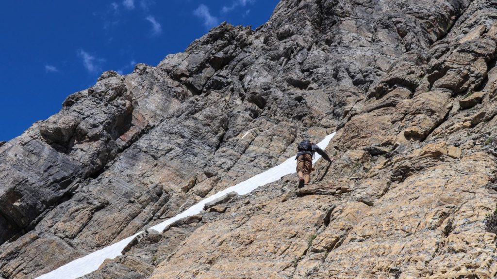
“It took us a little longer to climb up the gully north of Holland Peak, however, as rockfall was a big problem. One after the other, we solo climbed up and waited for one another to make it safely. Everyone felt good as we got on the ridge, and we were ready to cruise.
“Finding a safe route across the first high point slowed our pace down, but we decided to move on and hoped to get to Smith Creek Pass Trail before nightfall. Along the way, there were some Class 3 climbing routes and an exposed sharp ridge where falling was not an option; however, the farther north we moved, the milder the ridge became.
“At 9 p.m., we reached the peak just south of Cooney Mountain — our last mountain to traverse. Sunset was at 9:23 p.m. We had one more mountain peak in front of us, so we decided to skip Cooney Mountain, descend off the high point and drop down safely into the Smith Creek drainage. At sunset, we were at 7,800’. We put on our jackets, turned on our headlamps and ate some food before starting to contour the base of Cooney Mountain. We navigated on uneven and sloppy terrain down to 7,200’ on our way to the Smith Creek Trail.
“Using GPS devices, we got to the trail at 11 p.m., and we still had several miles to hike out. It was dark, and we were exhausted. At this point, we had been going 18 hours and moving slowly felt painful, but we had to stick with our slower member.
“After a slow hike out, we got back to the car at 3 a.m. We picked up our second car, stopped at Seeley Lake to take a power nap and drove the winding streets back to Missoula.
“I got home at 5:55 a.m. the next day, which was over 24 hours after our adventure had begun. My husband heard me come in and was glad I made it home but also that I had used my inReach Mini. Although we made it out safe, it had been one of my longest days out in the wilderness. Because he could track us and knew that I could text or call for help if I needed it, however, he always had peace of mind.”
NOTICE: To access the Iridium satellite network for live tracking and messaging, including SOS capabilities, an active satellite subscription is required. Some jurisdictions regulate or prohibit the use of satellite communications devices. It is the responsibility of the user to know and follow all applicable laws in the jurisdictions where the device is intended to be used.
The post Mountain Guide Recounts 10-hour Trip Turned 24-hour Ordeal appeared first on Garmin Blog.
Sample Block Quote
Praesent vestibulum congue tellus at fringilla. Curabitur vitae semper sem, eu convallis est. Cras felis nunc commodo loremous convallis vitae interdum non nisl. Maecenas ac est sit amet augue pharetra convallis nec danos.
Sample Paragraph Text
Praesent vestibulum congue tellus at fringilla. Curabitur vitae semper sem, eu convallis est. Cras felis nunc commodo eu convallis vitae interdum non nisl. Maecenas ac est sit amet augue pharetra convallis nec danos dui.
Cras suscipit quam et turpis eleifend vitae malesuada magna congue. Damus id ullamcorper neque. Sed vitae mi a mi pretium aliquet ac sed elitos. Pellentesque nulla eros accumsan quis justo at tincidunt lobortis denimes loremous. Suspendisse vestibulum lectus in lectus volutpat, ut dapibus purus pulvinar. Vestibulum sit amet auctor ipsum.
