Flying with ADS-B: Cincinnati, Ohio

Two weeks ago I embarked on a five-day long flight, encompassing over 2,000 nautical miles across 10 states, for a grand total of 18.5 hours. I knew it would be a bit of a challenge for this born-and-raised Midwestern pilot but what caught me by surprise is how much I would learn, experience and grow as a pilot.
To begin my East coast adventure, I found myself departing New Century Air Center here in Kansas City for a small, uncontrolled field on the East side of the Cincinnati metropolitan area. With a 194 knot ground speed and roughly 1:30 enroute, this would be the easiest leg of the week.
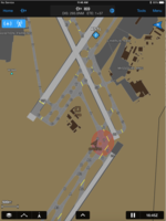
The enroute portion of my flight was pretty low-key. Crossing over the north side of the St. Louis area, I grabbed a screenshot of KSTL. In the image to the right you can see a brown target “FT48” indicates that the traffic is as a non-directional surface vehicle. You can also see an additional traffic target “CPZ5718” taxiing through a hotspot (represented by the red circle on Garmin Pilot) on taxiway Bravo. It goes without saying ADS-B equipage is growing and certainly enhances situational awareness throughout all phases of flight, including the airport environment.
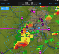
As I approached Cincinnati, mid-afternoon cumulus clouds accompanied several pop-up thunderstorms as I got closer to the city. This was no match for an aircraft equipped with the GDL 88 ADS-B In/Out datalink, as well as a GDL 69 SiriusXM satellite weather receiver (as I admitted in my previous post, there’s no doubt this Cirrus is well-equipped). While I was still 45 minutes from my destination just East of KCVG, thanks to FIS-B weather from the GDL 88 and Flight Stream 210, I closely monitored the development and trend of the weather on my iPad. Luckily, I didn’t have to work around it too much by the time I got near Cincinnati, but the controllers were polite enough to give me enough room to “deviate as necessary.”
With 10 minutes to go in my flight, Cincinnati approach took me right over top KCVG at 7000 feet before dropping me down to pattern altitude, where I got a great view of the downtown area post-thunderstorm. Thanks to the controllers for the unintentional excellent view!
Stay tuned next week as I continue East and make my way from Cincinnati to Frederick, Maryland – as you may have guessed, it is nothing but full of surprises!

The post Flying with ADS-B: Cincinnati, Ohio appeared first on Garmin Blog.
Sample Block Quote
Praesent vestibulum congue tellus at fringilla. Curabitur vitae semper sem, eu convallis est. Cras felis nunc commodo loremous convallis vitae interdum non nisl. Maecenas ac est sit amet augue pharetra convallis nec danos.
Sample Paragraph Text
Praesent vestibulum congue tellus at fringilla. Curabitur vitae semper sem, eu convallis est. Cras felis nunc commodo eu convallis vitae interdum non nisl. Maecenas ac est sit amet augue pharetra convallis nec danos dui.
Cras suscipit quam et turpis eleifend vitae malesuada magna congue. Damus id ullamcorper neque. Sed vitae mi a mi pretium aliquet ac sed elitos. Pellentesque nulla eros accumsan quis justo at tincidunt lobortis denimes loremous. Suspendisse vestibulum lectus in lectus volutpat, ut dapibus purus pulvinar. Vestibulum sit amet auctor ipsum.
