Downloadable US TrailMaps enhance equestrian and whitewater adventures
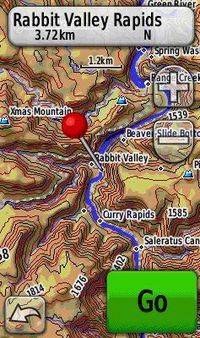
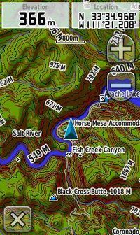 If you enjoy exploring the outdoors on land and on the water, you’ll be excited to hear that Garmin has teamed with US TrailMaps to offer equestrian trails and whitewater runs available for download from the Garmin website. Use the featured trail data in conjunction with Garmin topo map offerings such as TOPO 100K or TOPO U.S. 24K for a complete adventure. Conveniently download the maps to your GPS and you’ll add even more detail including complete trail information, useful points of interest, and trail and rapid names. When used with Garmin’s topo maps, US TrailMaps enhances your outdoor journey even more, plus it adds the most comprehensive whitewater or equestrian information available for your GPS.
US TrailMaps Whitewater contains 4,400 classified whitewater runs totaling over 42,000 miles. You can get detailed information such as rapids names and put-in and take-out access points for each run. US TrailMaps Equestrian contains over 20,000 miles of comprehensive equestrian trails and information for your GPS. You’ll have vital points of interest including the locations of hitching rails, watering holes, trailer parking areas, horse camping, tack shops, horse training, trailheads, visitor centers, stables, shelters, restrooms and picnic areas.
So take a moment to explore US TrailMaps and get the most out of every outing!
The post Downloadable US TrailMaps enhance equestrian and whitewater adventures appeared first on Garmin Blog.
Sample Block Quote
Praesent vestibulum congue tellus at fringilla. Curabitur vitae semper sem, eu convallis est. Cras felis nunc commodo loremous convallis vitae interdum non nisl. Maecenas ac est sit amet augue pharetra convallis nec danos.
Sample Paragraph Text
Praesent vestibulum congue tellus at fringilla. Curabitur vitae semper sem, eu convallis est. Cras felis nunc commodo eu convallis vitae interdum non nisl. Maecenas ac est sit amet augue pharetra convallis nec danos dui.
Cras suscipit quam et turpis eleifend vitae malesuada magna congue. Damus id ullamcorper neque. Sed vitae mi a mi pretium aliquet ac sed elitos. Pellentesque nulla eros accumsan quis justo at tincidunt lobortis denimes loremous. Suspendisse vestibulum lectus in lectus volutpat, ut dapibus purus pulvinar. Vestibulum sit amet auctor ipsum.
