5 More “YOU Take US There” Winners
Flying, Driving, or Hiking…

I received my Garmin eTrex Legend for Christmas 2005. My main ‘want’ for a GPS was for hunting. Some of those walks can take you back into the woods a long ways. Throw in nighttime and every thing looks VERY different. My GPS gives me an added level of comfort when walking in to a hunting area, knowing that I can always find my way back out.
I had heard about geocaching and it was on my list of things to try. I’ve now gotten thoroughly hooked on it and take my GPS everywhere I go, loaded up with geocaching waypoints. I’ve logged 38 geocaches and placed eight of my own, with more finds and hides to come. I even have my 12 year old son interested and he has learned the basic workings of my Garmin. Working as a flight nurse on an air medical helicopter, we sometimes transport specialty teams from one hospital to another. I recently made one of these flights to the hospital in Mayfield, KY. Having the better part of an hour to kill while we waited for the crew to pick up their patient, I fired up my Garmin. I was pleasantly surprised to find one of my preloaded waypoints was a geocache in front of the hospital, 1/10 of a mile from the helipad. I walked over to the little hospital park area, found and logged the cache and was back to the helicopter in no time at all.
It’s a great driving/navigational aid and I enjoy hooking it up to my laptop and driving with a moving map display. Of course, importing all of my geocache data into the mapping software is a big help on a geocaching trip.
Now that I’ve discovered the fun of using a GPS, I don’t ever see myself without one. If I can just convince my wife I already need an upgrade to the Garmin GPSMAP 60CSx . . . .
-John T.
Garmin in Nepal
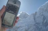
As an avid geocacher and hiker, I wanted to do the Everest base Camp trek in Nepal. This spring I booked my tickets and headed out with my GPSMAP 76 loaded with all of the geocaches in 5 countries. One such cache is the virtual at the top of Kala Pattar, a small peak from which one gets a great view of the top of Everest as well as the base camp below.
It was surprising how few of the Nepalis I met along the way had ever seen a GPS or knew what they did. Every time I showed them I got a good audience (most asked if it was a telephone).
After 10 days of hiking from Lukla, I arrived at Gorak Shep, the last inhabited spot in the Khumbu valley, where there are a few lodges for trekkers. The next morning I found Kala Pattar covered in snow, which made the climb up a bit treacherous. We started at 5:00am, and after a couple of hours we saw the sun rise over Everest.
I snapped a few pictures, but as the snow started to melt very rapidly, we had to descend quickly as the footing became iffy. The attached picture shows me holding the Garmin with Everest in the background.
-Kirk B.
Garmin and Hams
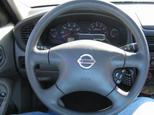 Besides geocaching, I also use my Garmin eTrex Vista (I also have an eTrex Legend) for Amateur Radio APRS.
My Gamin GPS is attached to the top console of my steering wheel and a cable attaches to my Ham Radio (Kenwood TM-D700A). The radio uses the Garmin’s NMEA output to track my location. Every minute it broadcasts my location which is picked up by Digipeters and rebroadcast. No matter where I am you can see my location, thanks to my Garmin.
-Chris R.
Phoenix, AZ
Geocaching in Wisconsin
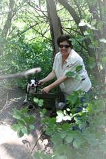
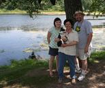 Glad we found your blog! Our family purchased in April our first GPS, a Garmin GPSMap 60CSx. While we use it to find our way, we are really enjoying our newfound hobby of geocaching. Photographs of our Boston Terrier pup, Geodog Briggs, have twice appeared on segments of “Caching with Condella”, an offering of the Fox Network affiliate in Milwaukee, Wisconsin, that introduces folks to this wonderful activity. We get to spend time together having fun, enjoying the outdoors, and spreading the Gospel through tracts we share on the geotrail and with other geocachers.
And recently I helped a friend lay out buoys that demarked the swim portion of a triathlon course on Delavan Lake in southeastern Wisconsin. The whole task, laying out 1/4-, 1/2- and 0.9-mile turning points and channel lane pairs, took just under an hour thanks to the amazing accuracy of our Garmin.
-Chummy
East Troy, WI
Stop and Smell the….Wild Flowers
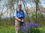
Hi. My name is Linda a.k.a. LL100 on Geocaching.com This was taken on a caching adventure on the Bartram trail in Western NC at a place called Jones Knob. Hope everyone enjoys the colorful wild flowers as much as I did.
-Linda R.
Hayesville, NC
The post 5 More “YOU Take US There” Winners appeared first on Garmin Blog.
Sample Block Quote
Praesent vestibulum congue tellus at fringilla. Curabitur vitae semper sem, eu convallis est. Cras felis nunc commodo loremous convallis vitae interdum non nisl. Maecenas ac est sit amet augue pharetra convallis nec danos.
Sample Paragraph Text
Praesent vestibulum congue tellus at fringilla. Curabitur vitae semper sem, eu convallis est. Cras felis nunc commodo eu convallis vitae interdum non nisl. Maecenas ac est sit amet augue pharetra convallis nec danos dui.
Cras suscipit quam et turpis eleifend vitae malesuada magna congue. Damus id ullamcorper neque. Sed vitae mi a mi pretium aliquet ac sed elitos. Pellentesque nulla eros accumsan quis justo at tincidunt lobortis denimes loremous. Suspendisse vestibulum lectus in lectus volutpat, ut dapibus purus pulvinar. Vestibulum sit amet auctor ipsum.

