Roger’s Runway: VNAV and the 430/530


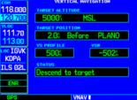
Last week on my way to the Sporty’s Fly-in I stopped in Chicago to visit the Garmin store. As always when flying into Chicago, as soon as I crossed into Illinois, Center called with an amendment to my fly flight plan. While the change in the flight plan was not a problem, Chicago approach did have a crossing restriction at the PLANO intersection. I went into the VNAV option on the GNS 530 to put PLANO in as my waypoint with a cross over altitude of 5000 MSL. Since approach did not tell me to descend right away, I waited until I had about 500 feet in the VSR data field. When the VSR data field indicated 500 FPM, I started the descent and was at 5000 feet MSL 2 NM prior to the PLANO intersection. The Vertical Navigation on the GNS 430/530 simplifies descent planning and crossing restrictions and no longer requires any mental mathematics.
I would give a special thanks to John and Dug (that is how it was spelled on his ID badge) for giving me an excellent tour of the Sporty’s facilities and the Clermont County Airport
The post Roger’s Runway: VNAV and the 430/530 appeared first on Garmin Blog.
Sample Block Quote
Praesent vestibulum congue tellus at fringilla. Curabitur vitae semper sem, eu convallis est. Cras felis nunc commodo loremous convallis vitae interdum non nisl. Maecenas ac est sit amet augue pharetra convallis nec danos.
Sample Paragraph Text
Praesent vestibulum congue tellus at fringilla. Curabitur vitae semper sem, eu convallis est. Cras felis nunc commodo eu convallis vitae interdum non nisl. Maecenas ac est sit amet augue pharetra convallis nec danos dui.
Cras suscipit quam et turpis eleifend vitae malesuada magna congue. Damus id ullamcorper neque. Sed vitae mi a mi pretium aliquet ac sed elitos. Pellentesque nulla eros accumsan quis justo at tincidunt lobortis denimes loremous. Suspendisse vestibulum lectus in lectus volutpat, ut dapibus purus pulvinar. Vestibulum sit amet auctor ipsum.

