Plan a route, geotag photos with BaseCamp, now free for Mac and PC

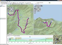
 If you’re heading into the great outdoors, either for a long week of camping or a quick day of hiking, you can quickly survey the land and easily plan your adventure with BaseCamp, a free software utility for Mac or PC that lets you view and organize your maps, waypoints, routes
and tracks and send them to your Garmin GPS device. You can click here to learn more about BaseCamp’s many uses, but in a nutshell, this free download:
- Allows you to view the vivid details of 24K or 100K topographic maps and other topographic data from Garmin
- Displays maps in 2-D or 3-D, including elevation profiles, and allows you to view and rotate them at any angle
- Allows you to create waypoints and routes on your computer and transfer maps, waypoints, routes, tracks and geotagged photos between your computer and your Garmin device
- Shows animated playback of routes and tracks over time
- Supports geotagged photos
- Lets you easily organize data into folders
- Prints full-page, color maps
- Exports user data for viewing in Google Earth

- Includes advanced geocaching support; can import data from geocaching.com
So before you venture outdoors, spend a little time with BaseCamp and make your outing that much more efficient and enjoyable.
The post Plan a route, geotag photos with BaseCamp, now free for Mac and PC appeared first on Garmin Blog.
Sample Block Quote
Praesent vestibulum congue tellus at fringilla. Curabitur vitae semper sem, eu convallis est. Cras felis nunc commodo loremous convallis vitae interdum non nisl. Maecenas ac est sit amet augue pharetra convallis nec danos.
Sample Paragraph Text
Praesent vestibulum congue tellus at fringilla. Curabitur vitae semper sem, eu convallis est. Cras felis nunc commodo eu convallis vitae interdum non nisl. Maecenas ac est sit amet augue pharetra convallis nec danos dui.
Cras suscipit quam et turpis eleifend vitae malesuada magna congue. Damus id ullamcorper neque. Sed vitae mi a mi pretium aliquet ac sed elitos. Pellentesque nulla eros accumsan quis justo at tincidunt lobortis denimes loremous. Suspendisse vestibulum lectus in lectus volutpat, ut dapibus purus pulvinar. Vestibulum sit amet auctor ipsum.

