Outdoor options expand with new Oregon units, Garmin Connect and Custom Maps
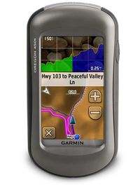 Responsive to the touch of a finger, yet resistant to the rigors of nature, Oregon 450t and Oregon 450 simplify navigation through a glove-friendly touchscreen interface. Making this an outstanding GPS for hikers braving the elements. This bright 3” color display is easier than ever to read and use in all conditions. Other key upgrades include user-selectable dashboards, enhanced track navigation, high-speed USB for faster map transfers with your computer, photo navigation and the 3-axis tilt-compensated electronic compass, which shows your heading even when you’re standing still, without the need to hold it level. The new dashboards give users the ability to customize the appearance of various pages on your Oregon, including the geocaching, compass, stopwatch and elevation functions. For hikers, cyclists and trail runners, the enhanced track navigation will prove especially useful. When navigating to a destination on an active track, users will see the changes in elevation ahead of them as well as where they’ve been. Also, waypoints and other key locations along the active route – such as start, end and high and low elevation points – now appear on the map and active route pages. The new Oregon units also include a barometric altimeter, paperless geocaching and wireless exchange of tracks, waypoints, routes and geocaches with compatible Oregon, Dakota, Colorado and Foretrex devices.
Both units boast a worldwide shaded relief basemap, and Oregon 450t adds preloaded 100K topographic maps for the entire United States and state-of-the-art 3D elevation perspective. Coverage on the 450t includes major trails, urban and rural roads, interstates, highways, coastlines, rivers and lakes as well as national, state and local parks, forests and wilderness areas. In addition, you can search for points of interest by name or proximity to your location and view descriptive details for terrain contours, topo elevations, summits and geographical points.
Customizing maps for your Garmin outdoor handheld – and downloading your activity afterward – were never easier. Through a few simple steps, Garmin’s Custom Maps can bring the details, labels and landmarks of your existing paper or electronic map to a compatible Garmin Oregon, Dakota or Colorado. Compatible with both PC and Mac, this free utility complements the myriad of mapping products already offered for Garmin devices, including City Navigator®, NT for turn-by-turn directions on city streets, Blue Chart® g2, for marine charting, and TOPO U.S. 24K and 100K map software for incredible terrain detail (each sold separately). The power of Custom Maps is exemplified through paper and digital maps labeled for specific events and purposes, such as a college graduation invitation that lists campus buildings; a roadmap of a parade, marathon, 5K or bike race; a park pamphlet showing trailheads; land-management maps of wildlife and game areas; or a historic illustration of an area as it once stood.
Experiences will live on long after the activity has ended, thanks to Garmin Connect’s newly announced compatibility with Garmin outdoor handhelds, adding an expansive new product line to the free-to-join online community of more than 17 million activities – with more than 38,000 new activities per day – for sharing, storing, analyzing and enjoying. Outdoor and fitness enthusiasts alike can share activities on Facebook and Twitter, export to Google Earth or relive the activity in table view, calendar view or on a variety of maps including our new embedded Google Earth view.
This December 2009 update also allows you to: easily upload to and from next-generation Garmin devices; manually upload .gpx files; send any track found at Garmin Connect in Explore to your Garmin Outdoor device for navigation; and export activity files in .gpx and .tcx format to use on third-party applications. Learn more and join Garmin Connect at http://connect.garmin.com.
Weighing only 6.8 ounces, the Oregon 450t and Oregon 450 last up to 16 hours on two AA batteries. Each device has a high-sensitivity GPS receiver with HotFixTM, which automatically calculates and stores critical satellite information and can use that information to quickly calculate a position. The new Oregon models have 850 MB of internal memory and a microSD card slot for photos and optional map data, and you can store up to 2,000 waypoints, 200 routes, 5,000 caches and a tracklog of up to 10,000 points and 200 saved tracks. Geocachers can help the environment and be more efficient by going paperless with Oregon by quickly downloading cache information directly to the device. Oregon stores and displays key information such as location, terrain, difficulty, hints and description, so that you don’t have to tote printouts with you. Learn more about geocaching, getting started and going paperless at www.garmin.com/geocaching.
The post Outdoor options expand with new Oregon units, Garmin Connect and Custom Maps appeared first on Garmin Blog.
Sample Block Quote
Praesent vestibulum congue tellus at fringilla. Curabitur vitae semper sem, eu convallis est. Cras felis nunc commodo loremous convallis vitae interdum non nisl. Maecenas ac est sit amet augue pharetra convallis nec danos.
Sample Paragraph Text
Praesent vestibulum congue tellus at fringilla. Curabitur vitae semper sem, eu convallis est. Cras felis nunc commodo eu convallis vitae interdum non nisl. Maecenas ac est sit amet augue pharetra convallis nec danos dui.
Cras suscipit quam et turpis eleifend vitae malesuada magna congue. Damus id ullamcorper neque. Sed vitae mi a mi pretium aliquet ac sed elitos. Pellentesque nulla eros accumsan quis justo at tincidunt lobortis denimes loremous. Suspendisse vestibulum lectus in lectus volutpat, ut dapibus purus pulvinar. Vestibulum sit amet auctor ipsum.
