Hitting the Road with Montana 680t
The holiday season has arrived, and for some of you that could mean hitting the road for some outdoor adventures. This year travel with confidence with our new Montana 680t handheld GPS. Equipped with an array of compatible mounts, Montana 680t is ready for any escapade. The handheld is designed for use on ATVs, boats, or even in your car. Use the auto mount with City Navigator® NT maps for spoken, turn-by-turn driving directions, or the rugged mount for your motorcycle or ATV.
You can literally go anywhere with Montana 680t – land or water – and it’s simple to add more maps to the device. You can download TOPO U.S. 24K maps and hit the trail, plug in BlueChart® g2 preloaded cards for a day on the water, or load City Navigator map data for turn-by-turn driving directions. You can even add satellite images to your maps with the included 1-year subscription of BirdsEye Satellite Imagery, or transform paper maps into files downloaded to your Montana with Custom Maps.
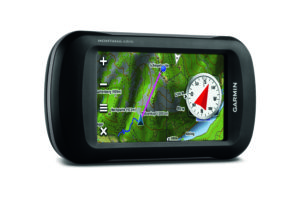
Like a lot of our outdoor products, the Montana 608t has a built-in 3-axis tilt-compensated electronic compass, which shows your heading even if you’re on the move or not holding it level. The barometric altimeter tracks changes in pressure to pinpoint your precise altitude, and you can use it to plot barometric pressure over time to help keep an eye on changing weather conditions. With its high-sensitivity GPS and GLONASS reception, WAAS-enabled receiver and HotFix satellite prediction, Montana 680t locates your position quickly and precisely. Whether you’re deep in the woods or near tall buildings and trees, you can count on Montana 680t.
Out and about but forgot your camera? No worries. With Montana 680t you can capture locations and memories with its built-in 8 megapixel digital camera. Each photo is automatically geotagged with coordinates, allowing you to navigate back to that exact spot in the future.
Planning a trip? Next time use BaseCamp. This free trip-planning software even allows you to create Garmin Adventures that you can share with friends, family or fellow explorers. BaseCamp displays topographic map data in 2-D or 3-D on your computer screen, including contour lines and elevation profiles.
Don’t forget to share your adventures with us on Facebook, Twitter, and Instagram using hashtag #HaveNoLimits.
The post Hitting the Road with Montana 680t appeared first on Garmin Blog.
Sample Block Quote
Praesent vestibulum congue tellus at fringilla. Curabitur vitae semper sem, eu convallis est. Cras felis nunc commodo loremous convallis vitae interdum non nisl. Maecenas ac est sit amet augue pharetra convallis nec danos.
Sample Paragraph Text
Praesent vestibulum congue tellus at fringilla. Curabitur vitae semper sem, eu convallis est. Cras felis nunc commodo eu convallis vitae interdum non nisl. Maecenas ac est sit amet augue pharetra convallis nec danos dui.
Cras suscipit quam et turpis eleifend vitae malesuada magna congue. Damus id ullamcorper neque. Sed vitae mi a mi pretium aliquet ac sed elitos. Pellentesque nulla eros accumsan quis justo at tincidunt lobortis denimes loremous. Suspendisse vestibulum lectus in lectus volutpat, ut dapibus purus pulvinar. Vestibulum sit amet auctor ipsum.
