Garmin offers Canadian FliteCharts!
You have been asking and we’ve been listening! Pilot’s
around the world update their Garmin certified and portable GPS units on our flyGarmin website and we’re
excited to offer our customers even more options. For pilots flying into and
out of Canada, the option to download approach chart data is now available!
 Canadian FliteCharts are available for a wide range of
Garmin portables and certified avionics, such as:
- GTN 750
- GMX 200
- G500/G600
- G3X
- G900X
- G950
- G1000, G2000, G3000, G5000
- aera 795/796
- GPSMAP 695/696
For some products, FliteCharts for both the
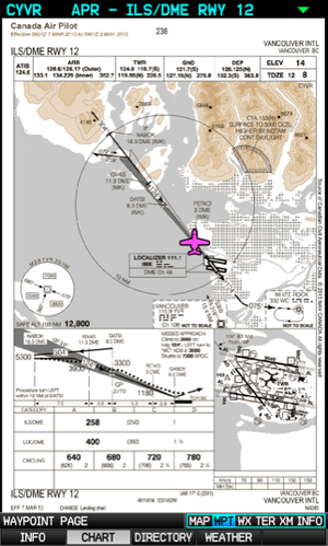
United States and Canada are also geo-referenced. Not familiar with the geo-referencing
feature? Simply put, a magenta aircraft is overlaid on top of the approach
chart, which represents your location on the approach.
Offering coverage for over 450 airports in Canada, Garmin’s
FliteChart database is available starting at $74.95 as a one-time purchase and
download. For pilots who find themselves regularly flying between the United
States and Canada, an annual subscription for North America is available as
well, starting at $299.95. Visit flyGarmin to download a comprehensive aviation
database price guide.
The post Garmin offers Canadian FliteCharts! appeared first on Garmin Blog.
Sample Block Quote
Praesent vestibulum congue tellus at fringilla. Curabitur vitae semper sem, eu convallis est. Cras felis nunc commodo loremous convallis vitae interdum non nisl. Maecenas ac est sit amet augue pharetra convallis nec danos.
Sample Paragraph Text
Praesent vestibulum congue tellus at fringilla. Curabitur vitae semper sem, eu convallis est. Cras felis nunc commodo eu convallis vitae interdum non nisl. Maecenas ac est sit amet augue pharetra convallis nec danos dui.
Cras suscipit quam et turpis eleifend vitae malesuada magna congue. Damus id ullamcorper neque. Sed vitae mi a mi pretium aliquet ac sed elitos. Pellentesque nulla eros accumsan quis justo at tincidunt lobortis denimes loremous. Suspendisse vestibulum lectus in lectus volutpat, ut dapibus purus pulvinar. Vestibulum sit amet auctor ipsum.

