Garmin HuntView: Hunting GPS Maps Now Available for 32 States
Garmin has once again expanded its HuntView hunting GPS maps, which are now available to purchase for 32 states. HuntView is an easy-to-use solution for hunters and outdoorsmen. There are no time-consuming downloads – just simply insert the microSD card into your Garmin handheld GPS and you’re ready to go!
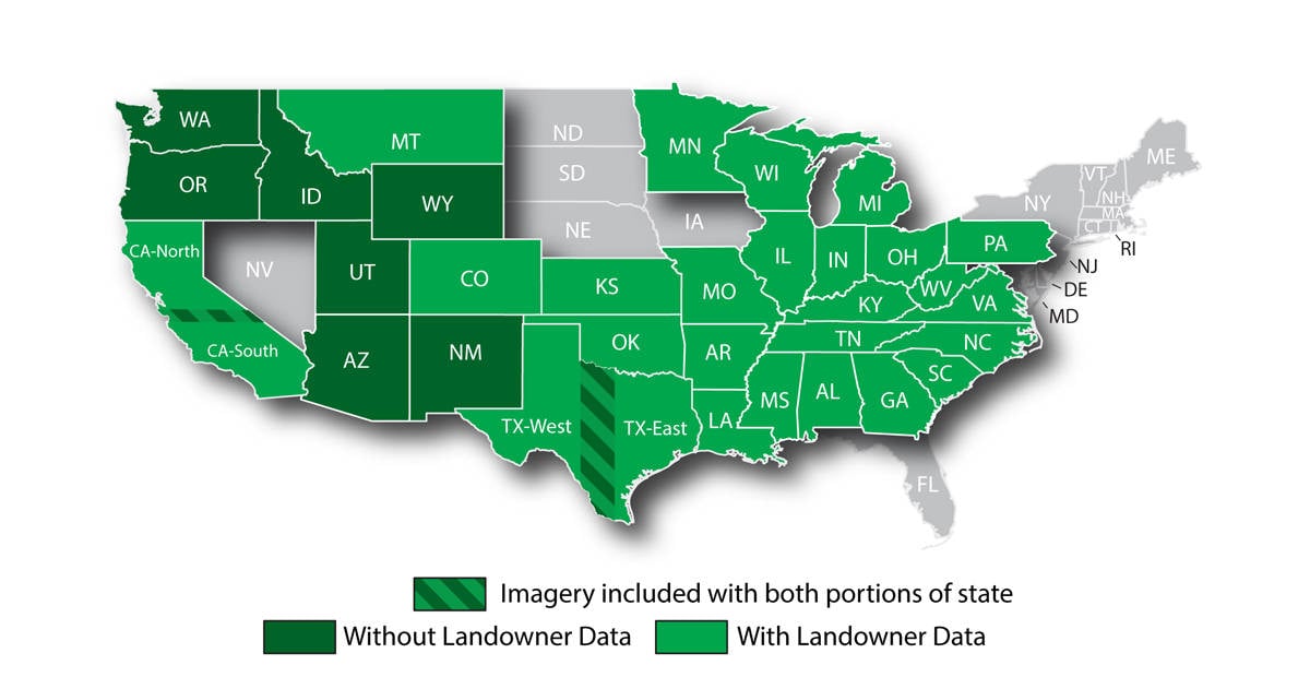 HuntView’s built-in BirdsEye Satellite Imagery will help you begin scouting for your next big adventure. With the exception of several western states (see map above), HuntView maps show landowner names and boundaries, so you know who to contact for permission to hunt certain pieces of private land you’ve been eyeing. HuntView will also show you public land types and boundaries, such as BLM, WPA, WMA, National forests, National parks and more.
Whether you’re chasing big game or letting your bird dogs or hounds loose, HuntView is compatible with a long list of devices, from the DriveTrack 70 or Alpha 100, to your Rino 6xx/7xx, Montana 6xx series handhelds, and more!
Click on the links below to learn more about HuntView hunting GPS maps for your state:
- Alabama
- Arizona
- Arkansas
- California (North and South)
- Colorado
- Georgia
- Idaho
- Illinois
- Indiana
- Kansas
- Kentucky
- Louisiana
- Michigan
- Minnesota
- Mississippi
- Missouri
- Montana
- New Mexico
- North Carolina
- Ohio
- Oklahoma
- Oregon
- Pennsylvania
- South Carolina
- Tennessee
- Texas (East and West)
- Utah
- Virginia
- Washington
- West Virginia
- Wisconsin
- Wyoming
Head to your local Garmin dealer or garmin.com to check out our extensive line of rugged handheld GPS units that are built for the outdoors and made to accommodate HuntView maps.
Follow Garmin Fish & Hunt on social media and share your fishing and hunting photos with us using #FishGarmin and #HuntGarmin.
The post Garmin HuntView: Hunting GPS Maps Now Available for 32 States appeared first on Garmin Blog.
Sample Block Quote
Praesent vestibulum congue tellus at fringilla. Curabitur vitae semper sem, eu convallis est. Cras felis nunc commodo loremous convallis vitae interdum non nisl. Maecenas ac est sit amet augue pharetra convallis nec danos.
Sample Paragraph Text
Praesent vestibulum congue tellus at fringilla. Curabitur vitae semper sem, eu convallis est. Cras felis nunc commodo eu convallis vitae interdum non nisl. Maecenas ac est sit amet augue pharetra convallis nec danos dui.
Cras suscipit quam et turpis eleifend vitae malesuada magna congue. Damus id ullamcorper neque. Sed vitae mi a mi pretium aliquet ac sed elitos. Pellentesque nulla eros accumsan quis justo at tincidunt lobortis denimes loremous. Suspendisse vestibulum lectus in lectus volutpat, ut dapibus purus pulvinar. Vestibulum sit amet auctor ipsum.
