Flying with Garmin Pilot Series, Part 2: Navigating the Moving Map
Last week we kicked off our six-part Garmin Pilot blog series by highlighting features that make flight planning a breeze within Garmin Pilot, including loading airways, selecting preferred routes and graphical flight planning. This week, we’re going to take an in-depth look at using the moving map within Garmin Pilot and all of the capabilities it has to make finding important information easy!
Rich, Interactive Maps
Garmin Pilot offers state-of-the-art interactive maps, which provide coverage around the world. Jeppesen and Garmin’s navigation data combine for streamlined flight planning and access to comprehensive navigation information. These maps are highly configurable so you can customize the display of charts, weather overlays, terrain and obstacles in split screen or full screen view, so a variety of information can be displayed simultaneously.
Charts, Charts… and more Charts!
VFR sectionals, World Aeronautical Charts (WAC), IFR low and high enroute charts are all easy to access by selecting the Map Layer icon in the lower left-hand corner of the map page. These charts are easily accessible on the ground or in-flight so you always have the option to call up a variety of charts tailored to your particular flight.
Global Weather
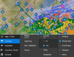
Weather information from around the world (including the U.S., Europe and Canada) such as METARs, TAFs, AIRMETs, SIGMETs, NOTAMs and winds aloft may be displayed graphically as an overlay on the moving map page. Simultaneously overlay any of these weather products on the map alongside your route of flight to determine if precipitation or cloud cover will impact your flight, at a glance!
Radial Menu
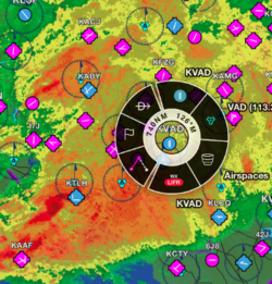
The unique Radial Menu is one of Lucy’s favorite features and one that offers easy onscreen access to navigation features. Via the Radial Menu, easily create a user waypoint, navigate Direct-To, view current weather conditions, check airport and/or NAVAID information, and more. Throughout my pre-flight planning and in-flight navigating, I find the Radio Menu to be one of the more popular features I use on the moving map!
NavTrack
The exclusive NavTrack feature allows you to “look ahead” and preview any particular flight that is within Garmin Pilot. By developing a flight plan and selecting split screen mode, you may access NavTrack and slide the navigation bar along the bottom to view a variety of information along your route, including METARs, TAFs, PIREPs and more.
These are just a few tips available to you within Garmin Pilot, which give you access to more information whether you’re in-flight or on the ground. If you’d like to try out some of these tips for yourself, download Garmin Pilot a free, 30-day trial from the iTunes App store or Google Play store.
Stay tuned next week for Part 3 of our Garmin Pilot blog series where we’ll discuss how to leverage the Trip Planning feature to make the most of your flight planning!
The post Flying with Garmin Pilot Series, Part 2: Navigating the Moving Map appeared first on Garmin Blog.
Sample Block Quote
Praesent vestibulum congue tellus at fringilla. Curabitur vitae semper sem, eu convallis est. Cras felis nunc commodo loremous convallis vitae interdum non nisl. Maecenas ac est sit amet augue pharetra convallis nec danos.
Sample Paragraph Text
Praesent vestibulum congue tellus at fringilla. Curabitur vitae semper sem, eu convallis est. Cras felis nunc commodo eu convallis vitae interdum non nisl. Maecenas ac est sit amet augue pharetra convallis nec danos dui.
Cras suscipit quam et turpis eleifend vitae malesuada magna congue. Damus id ullamcorper neque. Sed vitae mi a mi pretium aliquet ac sed elitos. Pellentesque nulla eros accumsan quis justo at tincidunt lobortis denimes loremous. Suspendisse vestibulum lectus in lectus volutpat, ut dapibus purus pulvinar. Vestibulum sit amet auctor ipsum.


