Discover, Explore and Create New Adventures with Updated Rails-to-Trails Maps
 When surfing our many on-the-trail mapping offerings you may have stumbled across the Rails-to-Trails Conservancy (RTC) trail maps, and wondered what the heck that is. Well, RTC is a nonprofit organization based in Washington, D.C., whose mission is to create a nationwide network of trails from former rail lines and connecting corridors to build he
 althier places for healthier people. With that being said, you can see why we have decided to offer these trail maps to our users and continue to grow the options available to download.
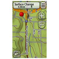
The R TC trail maps now include even more trails and Points of Interests (POI’s) than ever before. Each RTC region in the U.S. was recently updated to add more detailed trail routes and POI’s so you can get out and explore new and exciting areas. POI’s added include trailheads, parking locations, bridges, tunnels, surface changes, restrooms, drinking fountains and many more. RTC’s popular trail finder site, www.TrailLink.com, also features updated comprehensive trail information, some of which include surfaces, allowable uses, descriptions, and pictures. Using RTC’s trail finder site is
 a quick and easy way to discover thousands of miles of bike trails, walking trails, equestrian trails, and hiking and running trails to help guide your next adventure.
To enhance your outdoor experience with these great maps you can also pair RTC’s trail data with Garmin’s TOPO 24K regional maps. Download one of the RTC six regions to your compatible unit for only $9.99!
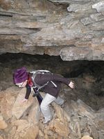
Thank  you to Melody, an avid hiker and climber who recently took out her GPSMAP62sc loaded with RTC south-central on an adventure to the Buffalo River in Arkansas, for the great photos!
Now get out and explore!!
Rails-to-Trails Conservancy (RTC) Trail maps now include even more trails and Points of Interests (POI’s) than before. Each RTC region in the U.S. was recently updated to add more detailed trail routes and POI’s so you can have even more outdoor trail experiences. POI’s include trailheads, parking locations, bridges, tunnels, surface changes, restrooms, drinking fountains and more. RTC’s popular trail finder site, www.TrailLink.com , also features updated comprehensive trail information, including surfaces, allowable uses, descriptions, pictures and more. Simply use RTC’s trail finder site to discover thousands of miles of bike trails, walking trails, equestrian trails, and hiking and running trails. This site is perfect if you are searching for a new route, photos, or even reviews.
Garmin features six RTC regions in the U.S., including West, Southwest, North Central, South Central, Northeast, and Southeast. You can view each region and it’s coverage by visiting the Garmin website at www.garmin.com/us/maps/onthetrail and by choosing the Rails-to-Trails Conservancy Trail Maps heading.
You can also pair RTC’s trail data with Garmin’s TOPO 24K regional maps to enhance your outdoor adventure even more. Download one of the RTC regions to your compatible unit today for only $9.99! Compatible units include: Colorado® series, Oregon® series, Dakota® series, Montana series, Edge® 605/705/800, eTrex® 20/30, GPSMAP® 60CSx, 60Cx, 62, 62s, 62sc, 62st, 62stc, 76CSx, 76Cx, 78, 78s, 78sc, nuvi® 500/550, Rino® 520HCx, 530HCx, 6xx, Astro® 220/320, eTrex Legend® Cx, HCx, eTrex Venture® Cx, eTrex Vista® Cx, HCx
The post Discover, Explore and Create New Adventures with Updated Rails-to-Trails Maps appeared first on Garmin Blog.
Sample Block Quote
Praesent vestibulum congue tellus at fringilla. Curabitur vitae semper sem, eu convallis est. Cras felis nunc commodo loremous convallis vitae interdum non nisl. Maecenas ac est sit amet augue pharetra convallis nec danos.
Sample Paragraph Text
Praesent vestibulum congue tellus at fringilla. Curabitur vitae semper sem, eu convallis est. Cras felis nunc commodo eu convallis vitae interdum non nisl. Maecenas ac est sit amet augue pharetra convallis nec danos dui.
Cras suscipit quam et turpis eleifend vitae malesuada magna congue. Damus id ullamcorper neque. Sed vitae mi a mi pretium aliquet ac sed elitos. Pellentesque nulla eros accumsan quis justo at tincidunt lobortis denimes loremous. Suspendisse vestibulum lectus in lectus volutpat, ut dapibus purus pulvinar. Vestibulum sit amet auctor ipsum.

