British Antarctic Survey Upgrades Twin Otter with G950
Late last year, the British Antarctic Survey (BAS) – Natural Environment Research Council completed their first Twin Otter G950 integrated flight deck upgrade for their fleet of specialized aircraft. Aviation has long been a means of travel to and from Antarctica, but the additional services these aircraft provide is invaluable to their goal of expanding polar science and operations. BAS Project Pilot Andrew Vidamour took time to discuss their organization’s unique efforts and why they chose the G950 for their extreme mission. Here is their story:
For over 60 years, the British Antarctic Survey (BAS) has been responsible for most of the UK’s scientific research in Antarctica. The BAS Air Unit operates and manages an integrated fleet of aircraft for research, survey and polar logistics. With the aim to execute a challenging programme of airborne science and logistics and to provide a worldwide capability that gives the environmental science community access to a range of aircraft platforms and instrumentation. The fleet comprises of five specially adapted aircraft (De Havilland Canada Dash 7 and four Twin Otters).
At the beginning of each season the aircrew – eight pilots and four engineers – ferry the aircraft south from their base in the northern hemisphere. Flights in the Antarctic take place during the Antarctic summer, between October and March, as winter darkness and very cold temperatures prevent flying at other times.
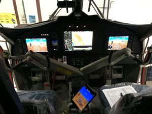
Upgrade taking place at Rocky Mountain Aircraft’s Hangar in Calgary. The pilot’s iPad uses Flightstream 210 to communicate with G950 and receive GPS position data for custom Antarctic charts.
In 2012 the Air Unit embarked upon an avionics upgrade program for our fleet of De Havilland DHC-6 aircraft. The list of requirements included operation down to -40°C without pre-heating and the ability to navigate at the earth’s magnetic and geographic poles. After various evaluations and research into other avionics fits we settled on the Garmin 950 Integrated Flight Deck STC offered by Aerocorp Avionic Solutions.
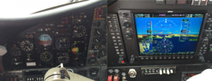
Old versus new primary flight instruments
Items that influenced the decision were:
- An AHRS that would allow Grid Navigation (the GRS 7800)
- Ability to carry out nearly the full range of RNP Approaches (RNP AR not currently supported) and operate in PBN airspace.
- ADS-B Out and In on 1090Mhz and UAT.
- Compliance with European Enhanced Mode S.
- Integrated Sat Phone (GSR 56) with voice and messaging.
- The expansion of the G950/G1000 line of avionics and its growing list of optional equipment.
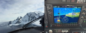
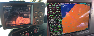
An example of the terrain features along the coast of the Antarctic Peninsula and the corresponding view of the G950 synthetic vision on the PFD.
The aircraft upgrade was carried out by Rocky Mountain Aircraft of Calgary, Alberta in 2015. The first aircraft to be upgraded was a DHC-6 300 series VP-FBL and was ferried from Calgary Springbank airport to our operating base at Rothera Research Station in Antarctica, a ferry flight of 10 days. Once in Antarctica the aircraft carried out various tasks including deployment of science staff and equipment to Glaciers and ice shelves, and cargo logistics to field depots involving carriage of 55 USGAL drums of Jet Fuel. They also completed aerial survey of geographic features, seal and penguin colony’s, plus training of additional staff on the new Garmin cockpit.
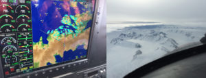
An excellent feature is being able to overlay weather radar information onto the moving map allowing a cross check of terrain with the GPS mapping.
The major test of the new flight deck was during the month and a half long deployment to the Antarctic High Plateau where the temperatures reached -32’C at an altitude of 8000ft. The aircraft and the flight deck was able to conduct a battery start without external assistance during the start sequence after being cold soaked on one occasion for 48 hrs.
On the left, a rarely seen example of what happens to a GPS display when approaching the South Pole. The majority of GPS maps use a form of Mercator projection which doesn’t like the idea that you are approaching the edge of the world. On the right, the radar return is the large South Pole station.
The survey culminated with a 2-week detachment to the USAP station at the South Pole at an elevation in excess of 9000ft, with temperatures constant at around -30’C. The aircraft started and operated once again without issue, although heaters were now used at the South Pole to pre-heat the aircraft.
After the completion of its season in Antarctica, the snag list for the aircraft upon returning to its Calgary start point was exceptionally small considering this was only the second Twin Otter to be equipped with the G950 flight deck. The Garmin G950 performs well and has also been installed in two other BAS aircraft during 2016 and another scheduled due for upgrade in 2017.
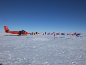
VP-FBL and its G950 flight deck were subjected to the rigours of the South Pole for a 2-week deployment, shown here next to the ceremonial South Pole marker.
-Story by Andrew Vidamour, DHC-6 Garmin G950 Project Pilot
We would like to extend a special thanks to BAS Project Pilot Andrew Vidamour and the entire British Antarctic Survey team for sharing their story. For more Garmin aviation announcements, news and stories, follow us on Facebook, Twitter and Instagram – plus be sure to share all your aviation adventures with us using #flyGarmin.
The post British Antarctic Survey Upgrades Twin Otter with G950 appeared first on Garmin Blog.
Sample Block Quote
Praesent vestibulum congue tellus at fringilla. Curabitur vitae semper sem, eu convallis est. Cras felis nunc commodo loremous convallis vitae interdum non nisl. Maecenas ac est sit amet augue pharetra convallis nec danos.
Sample Paragraph Text
Praesent vestibulum congue tellus at fringilla. Curabitur vitae semper sem, eu convallis est. Cras felis nunc commodo eu convallis vitae interdum non nisl. Maecenas ac est sit amet augue pharetra convallis nec danos dui.
Cras suscipit quam et turpis eleifend vitae malesuada magna congue. Damus id ullamcorper neque. Sed vitae mi a mi pretium aliquet ac sed elitos. Pellentesque nulla eros accumsan quis justo at tincidunt lobortis denimes loremous. Suspendisse vestibulum lectus in lectus volutpat, ut dapibus purus pulvinar. Vestibulum sit amet auctor ipsum.
