Beyond Just Steps: Thru-Hiking New Zealand’s Te Araroa
By Kole Krieger – Thru-hiker for Comfort Theory – New Zealand
I still can’t believe it. I just walked the length of New Zealand. With a crew of three other thru-hikers and two cameramen, we had all odds stacked up against us. It’s uncommon, and borderline absurd, to attempt a five-month thru-hike with a large group from start to end. We felt the struggles on a daily basis. Some days it took hours to make decisions. I embraced the role of guiding our crazy expedition, making most of the calls pertaining to weather, distance, and safety. Somewhere along the way of leading our squad, I changed internally. It’s hard to explain, but my perspective shifted. I began to walk the Te Araroa with eyes and mind wide open, and in return the trail unveiled unimaginable experiences. While it’s difficult to put a finger on these intangible changes, I was able to witness physical changes with the help of my Fenix 3.
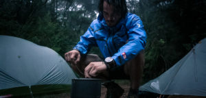
My fenix 3 counted all 4,209,682 steps I took on the Te Araroa. What it didn’t count was the countless amount of times I looked to it for barometric weather changes, altitude, directions, calorie count or any of the other features.
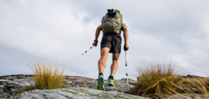
In the thru-hiking society it is a common occurrence to have heated discussions with regards to the weight of packs and gear, but seldom does the conversation shift to our own personal weight. Many times this has to do with the fact that everyone has given up to the fact that we all are losing weight and for many, at an unhealthy rate. I was one of the rare people whom completed the trail this year and actually gained weight. Many people are confused and aren’t sure how I did this but it was because of the calorie counter widget. It constantly calculated my resting and active burn rate. It gave me a goal to eat every day and throughout the day. I knew I didn’t have control over how many miles I put in each day or how many mountains were ahead of me, but I could control how well fueled I was for what was to come. I knew with a simple glance downwards would give me the vital information I needed, especially if I needed fuel for the peak ahead or if I should stop to grab a bar out of my pack. Not only was this crucial to my health, but it also allowed me to enjoy the climbs far more with a fully fueled body. While many hikers finish long trails undernourished, I came out of the trail stronger and fitter than I went into it.
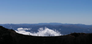
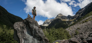
My fēnix 3 didn’t just take care of me, it took care of my team. In the northern part of the South Island lies a rigid chain of mountains, notoriously known as the most difficult of the TA, called the Richmond Ranges. People write in hut books, on forums and gossip around beers about the dangers Te Araroa hikers face here. This range is on the tip of everyone’s tongue as they nervously cross the safer North Island to the more remote South Island. Injury and death occur here because the mountains jut up from the ocean floor, creating a wall that stops all weather storms in their tracks and brews them overhead TA hikers. This section is one of the most remote of the whole South Island. If something goes wrong, you’re out of luck with service, and you’re a long way from walking out for help. It’s also a whopping 10 days long, which means any sort of planning around weather in nearly impossible. Hikers are often left stranded hundreds of feet up on dangerous scree mountain slopes with 20 to 30 feet of visibility when storms push in from the angry Tasman Sea or Pacific Ocean. During our trekking season two people had been helicoptered out with major injuries and the previous year a hiker had perished. As the team trail guide, I took the planning of this route very seriously. Along with discussions of the route and safely meetings, backcountry hut waypoints and routes were downloaded onto everyone’s fēnix.
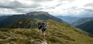
The hike and weather was fine up until day four, when my watch beeped unexpectedly. “Storm Alert.” The team and myself had already hiked some 10 miles up and down all day, over beautiful ridgelines, and with five hours to go until sunset we had high aspirations for the day. At the time of the beep we were currently debating heading over the highest peak to the Mt. Richmond hut, or if we should head 45 minutes off the trail to Old Man hut. We knew it would take somewhere around 3-4 hours to make it up and over Mt. Rintoul from our current location to the next hut. But if we went to Old Man hut it would be a total of an hour and a half of extra hiking, plus the 1000 ft. in added elevation change. Obviously no one had any desire to do extra on top of an already excruciating day.
The weather looked fine, but the alert bothered me. I consulted my fēnix and learned that the air pressure had vastly dropped over the last hour. I realized the haze that had set in over the ridgeline was actually the mountain preparing for an all-out battle with clouds we could not yet see. It was a tough decision but I decided to call it a day, suggesting to the group that we head to Old Man hut and leave the Mt. Rintoul summit push for tomorrow. The descent was rough and brutal on our already tired legs. I got some slack from fellow group members about the weather being clear enough that we could have made it over the mountain.
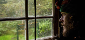
But sure enough, not more than ten minutes from the hut a fog set in and we realized we were in the clouds. The instant we arrived to Old Man hut the rain started to erupt. As the storm progressed we could hear the peaks above receiving a beating from the storm. The six of us sat around the fire playing checkers and telling jokes, distracting ourselves from the thought of how dangerously close we were to being stuck in exposed mountain top amidst a gnarly New Zealand cloud battle. The storm lasted until midday the next day. As it started to clear we all were more than thankful for the extra climb back to the trail from Old Man hut. Five days later, we made it out of the treacherous Richmond Ranges and felt like accomplished thru-hikers. We had passed our first test. The fenix wasn’t just a GPS guide to the trail. It became my friend, my trainer, my coach.
Even now after finishing the trail and coming back home to Portland I still wear it all day every day without fail. It tracks my sleeping habits, caloric intake and now it even makes sure I get up and walk around which used to never be an issue on the trail. Just as I had to adapt to a more civilized off-trail lifestyle, my fenix functions did the same. It now acts as my smart watch during business hours, giving me notifications for my next meeting, and it performs different functions far from walking, such as tracking my training runs or mountain bike rides.
Long walks create life-altering changes. Nowadays, when I’m presented with a difficult challenge, I think to myself that if I completed the Te Araroa, I can do just about anything. My fenix 3 was with me for a lot of those experiences and helped shape them. Because of that it will never lose a place on my wrist.
Comfort Theory‘s New Zealand project will culminate in a web series on OutsideTelevision.com. For more info on the premier head over to comforttheory.com or follow @thecomforttheory
The post Beyond Just Steps: Thru-Hiking New Zealand’s Te Araroa appeared first on Garmin Blog.
Sample Block Quote
Praesent vestibulum congue tellus at fringilla. Curabitur vitae semper sem, eu convallis est. Cras felis nunc commodo loremous convallis vitae interdum non nisl. Maecenas ac est sit amet augue pharetra convallis nec danos.
Sample Paragraph Text
Praesent vestibulum congue tellus at fringilla. Curabitur vitae semper sem, eu convallis est. Cras felis nunc commodo eu convallis vitae interdum non nisl. Maecenas ac est sit amet augue pharetra convallis nec danos dui.
Cras suscipit quam et turpis eleifend vitae malesuada magna congue. Damus id ullamcorper neque. Sed vitae mi a mi pretium aliquet ac sed elitos. Pellentesque nulla eros accumsan quis justo at tincidunt lobortis denimes loremous. Suspendisse vestibulum lectus in lectus volutpat, ut dapibus purus pulvinar. Vestibulum sit amet auctor ipsum.
